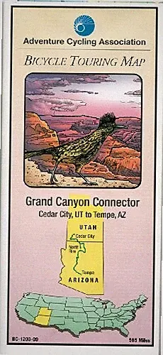
BICYCLE TOURING MAP: GRAND CANYON CONNECTOR By Adventure Cycling Association
This page is affiliate-supported. Prices and availability can change after the last marketplace refresh.
About this product
This is a folded bicycle touring map, titled 'Grand Canyon Connector,' published by the Adventure Cycling Association in 2009. Authored by Carla Majernick and ACA Staff, it provides navigational guidance for cycling through the Grand Canyon area. The map is designed for touring cyclists, featuring two pages of information in English, making it a practical resource for planning and executing bike trips in this specific region.
Our take
If you're planning a bicycle tour around the Grand Canyon, this map seems like a solid, focused resource. The fact that it's from the Adventure Cycling Association, specifically for the 'Grand Canyon Connector,' suggests a well-researched route. It's a folded map format, which is classic for touring, and while it only has two pages, that might mean it's highly concentrated on key information. The 2009 publication year is a consideration; some details like services or road conditions could have changed since then, but the core geography should remain accurate.
Pros & Cons
Pros
- Specific to Grand Canyon bicycle touring
- Authored by Adventure Cycling Association
- Traditional folded map format
Cons
- Publication year 2009 means some info might be dated
- Only 2 pages, potentially limited detail
Specifications
- ISBN-10 0935108734
- Book Title Bicycle Touring Map: Grand Canyon Connector
- Author Adventure Cycling Association, Carla Majernick, Aca Staff
- Language english
- Publisher Adventure Cycling Association
- Publication Name Adventure Cycling Association
Show all 11 specifications
- Publication Year
- 2009
- Format
- Folded Map
- Type
- Map
- Number Of Pages
- 2
- ISBN
- 0935108734